Red Basin, New Mexico, USA
THE RED BASIN PROJECT
100% OWNERSHIP
Historic reports indicate a clear path to success
Minor production reported from the district in the 1950’s.
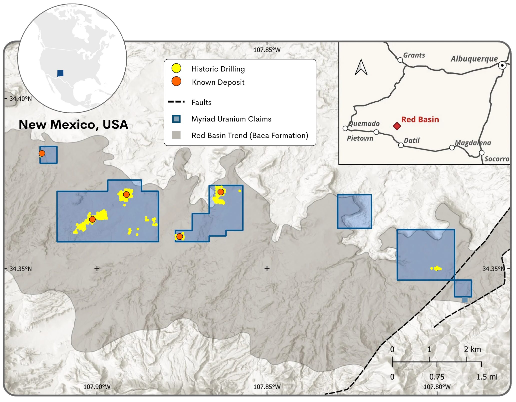
Historical exploration drilling Gulf Oil Corporation identified uranium and vanadium mineralization within the Myriad claim areas.
- 527 of 1,050 holes believed to have been drilled on the properties have been located in the field to date.
- Rio Grande Resources Corporation conducted a geologic and resource evaluation of the drill hole gamma ray electric logs in 2012 (information not currently available).
- Potential mineral endowment of the district is believed to be up to 45 Mlbs according to New Mexico Bureau of Mines and Mineral Resources (Chamberlin, 1981).
This estimate is historical and not current under NI 43-101. Myriad is not treating it as current. There has been insufficient exploration to define a mineral resource and it is uncertain if further exploration will result in the delineation of a mineral resource.
Note: For more information about historic resources refer to the section at the end of this page.
HIGH-RESOLUTION GROUND GEOPHYSICS AT RED BASIN
Earn-In Achieved + Modern Data Acquisition Completed
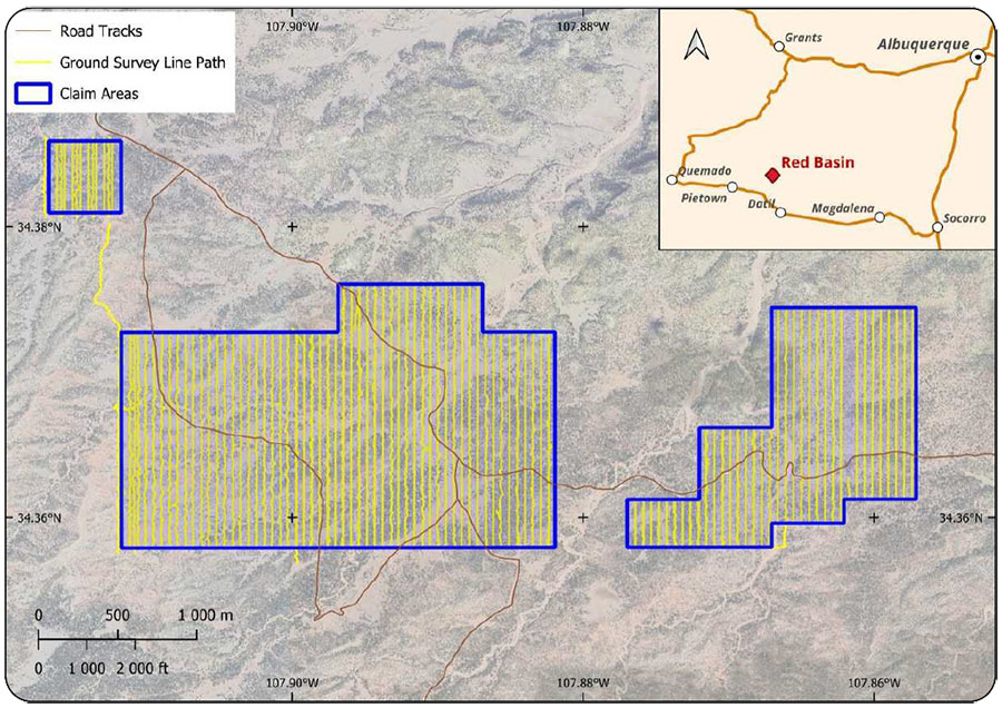
100% ownership confirmed following completion of required high-resolution ground surveys:
- Project is advancing toward a large-scale exploration permit supported by new geophysical data.
Data Acquisition Summary:
- Conducted at 50 m line spacing along a northsouth orientation
- 160 line-km ground magnetic survey, ~0.2 m sample spacing
- 142 line-km radiometric gamma survey, ~1 m sample spacing
Figure 1: Ground survey line paths for recorded data
RED BASIN PHOTO GALLERY
NOTES TO DISCLOSURE OF HISTORIC INFORMATION
Red Basin, New Mexico
The following sources of information are relevant to the historic resource or grade estimates referred to in this document:
– Hiner, J. and Bain, F. for First American Uranium, Inc. (2023). Red Basin Uranium/Vanadium Property National Instrument 43-101 Report.
Additional sources of information include the following:
-
Hiner, J. and Bain, F. for First American Uranium, Inc. (2023). Red Basin Uranium/Vanadium Property National Instrument 43-101 Report. Additional sources of information include the following:
-
Bachman, G.O., Baltz, E.H. and Griggs, R.L (1957). Reconnaissance of Geology and Uranium Occurrences of the Upper Alamosa Creek Valley, Catron County, New Mexico. Trace Elements Investigations Report 521. United States Department of the Interior Geological Survey.
-
Chamberlin, R.M. (1981). Uranium Potential of the Datil Mountains-Pietown Area, Catron County, New Mexico. New Mexico Bureau of Mines and Mineral Resources. Open-File Report No. 138.
-
McLemore, V.T. (1981). Uranium resources in New Mexico – discussion of the NURE program. New Mexico Bureau of Mines and Mineral Resources, in New Mexico Geology, v. 3, n. 4 pp. 54-58.
-
Halterman, L. (2007). A Uranium and Vanadium Prospect, New Mexico. Running Fox Resources.
-
McLemore, V.T. (2011). Uranium Resources in the Red Basin-Pietown District, Catron County, New Mexico. New Mexico Bureau of Geology and Mineral Resources, New Mexico Institute of Mining and Technology. Presentation to U2011 Conference, Casper, Wyoming.
The historic resources referred to here were estimated on the basis of more than 1,000 historic drill holes that are located on the property. The Department of Energy (DOE, 1980) estimated the Red Basin prospect to contain approximately 1.6 million pounds U O at an average grade of 0.31% U3O8. In 2012, Rio Grande Resources commenced a geologic evaluation of the drill hole gamma ray electric logs (perss. comm. – source reference not available). Stratigraphic cross-sections were constructed, two separate roll-fronts were mapped, and a resource estimate made. Using a grade times thickness (GT) cutoff of 0.25 and grade cutoff of 0.02%, an Indicated in-place resource of 500,000 pounds and an Inferred resource between 1.5 – 6.5 million pounds U3O8 was estimated, in accordance with definitions of the CIM Definition Standards for Mineral Resources & Mineral Reserves (2014). These estimates are not current under NI 43-101 and the reader is cautioned that historical resource estimates should not be relied upon to judge the quality of exploration potential of Red Basin. The data collection methods applied at the time are considered appropriate and reliable and the estimates derived from them are considered relevant. However, the resultant gamma logs and core assays that supported the resources were not available to the Qualified Person, therefore a complete and thorough review of the underlying data has not been possible. Estimates of target and district potential, although based on assumptions with technical merit, are speculative in nature and should be relied upon as an indication of future resources or reserves. A Qualified Person has not done sufficient work to classify the historical estimate as current mineral resources or mineral reserves; and the issuer is not treating the historical estimate as current mineral resources or mineral reserves. Inherent limitations of the historical estimates include that the nature of the mineralisation (fracture hosted) makes estimation from drill data less reliable than other deposit types (e.g. those that are thick and uniform). From Myriad’s viewpoint, limitations include that the Company has not been able to verify the data itself and that the estimate may be optimistic relative to subsequent work which applied a “delayed fission neutron” (DFN) factor to calculate grades. On the other hand, DFN is controversial, in that the approach is viewed by some experts as too conservative. Nevertheless, it was applied in later resource estimations by Union Pacific relating to Copper Mountain. In order to verify the historical estimates and potentially re-state them as current resources, a program of digitization of available data is required. This must be followed by re-logging and/or redrilling to generate new data to the extent necessary that it is comparable with the original data, or new data that can be used to establish the correlation and continuity of geology and grades between boreholes with sufficient confidence to estimate mineral resources.
RED BASIN URANIUM PROJECT
Myriad owns 100% of the Red Basin Uranium Project in New Mexico, USA
- Historical drilling in the district confirms that the Red Basin Project contains high-grade uranium minersalisation of 0.17%-0.31% that is near surface with signigicant potential for associated vanadium up to 1.64% V2O5.
- The mineralisation is in thick sections of rollfront deposits hosted in permeable sandstones from surface to depths of less than 450 feet.
- The broader Datil Mountains – Pietown area could contain 40 Mlbs or more of high-grade uranium with much of it potentially amenable to ISR.


